Home » Adventures » Black Hills » 1880 Train and Surrounding
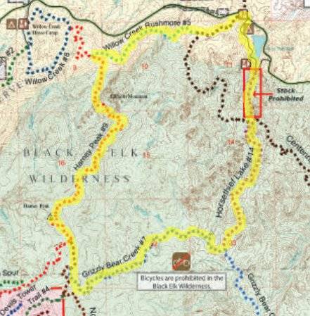
Route I trail ran
I started early out of camp to get in another trail run (this time without getting lost) and a train ride afterwards. I wanted to be running by 7, but reality made it closer to 8.
My planned loop went through the Black Elk Forest, starting form Horsethief Lake and reaching Harney Peak. The trail quickly became rocky and steep, and I resorted to power walking. Most of the way to Grizzly Bear Creek continued this way. There I could finally run again as the trail crossed it namesake creek several times. Towards the end though I was back to lots of climbing and resultant power walking.
I made the turn to Harney Peak, and as the map predicted the trail became more crowded. I finished the short length to the highest point between the Rocky Mountains and Pyrenees in Europe, and was greeted with an absolutely gorgeous view. Even with the busy trail at the end, hiking to this vista was worth it. Although only when I made the southern approach did I have a lot of company.
A mountain goat was also at the top. These animals were not indigenous to the Black Hills but were inadvertently introduced after escaping from a zoo.
Panoramic view from Harney Peak
On my way down I ran easily. The rocky and technical trail forced me to walk to avoid tripping and spraining an ankle. With the sun rising and myself descending from the cold heavens, the day also heated up.
I originally wanted to ride the 10 a.m. 1880 train, but that would not be possible with my “it did not look that far on the map” plan. I rescheduled from having a nice lunch before the next planned departure at noon, to scrambling to make sure I could even make that one. (Although back at my car I learned it really departed at 1:15, giving me plenty of time). I originally intended to take the CT to the Horsethief area and back to my car, but because of my perceived time crunch, the length of time I had been on my feet, and my lowering water reserves, I took a shortcut by taking the CT to Highway 224, and cutting through the campground to get back to my car.
I considered jumping in the lake afterwards, but that was disallowed to keep it pure. So I could only clean up in the parking lot before heading into town for a late lunch — I could only eat peanut butter sandwiches in a row so many times. Scientists have actually studied this subject in depth, conclusively determined the limit was “a couple of times.”

I boarded the 1880 trail from Hill City to Keystone and enjoyed the clickity clack of the train. The scenery along the route was very nice, as was the ride. The train had a stopover in Keystone, where I ate a delicious bowl of homemade ice cream. The train ride back was as enjoyable as the way out, and what you would expect from a restored, tourist train.
That afternoon I went mountain biking on the Little Spearfish and Rimrock Trails (79 and 80), planning to make a figure 8. I did not start on the Lower Loop until about 5:30 though and immediately discovered the trail was very narrow and overgrown. I could barely make any progress and very shortly I uncharacteristically turned around.
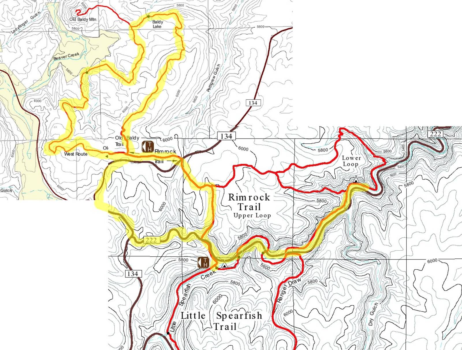
Route I biked
I tried the Spearfish Loop instead, but did not have high hopes. The trail looked slightly more passable, but still not good, and I did not even attempt it. I instead would take the Upper Loop, and if that was a bust, just ride on forest roads. From FR222 I started slogging my bike up a 45° slope. At the top of that short, but very steep section the trail was rideable. It intersected with Rimrock Trail and the path became rider friendly. In fact the Black Hills Mountain Bike Association had marked this trail with flags for one of their rides. I should have looked this group up beforehand for recommended routes, instead of picking my own from maps.
The path lead to Old Baldy Trail. The western half was very nice, and I stayed in the saddle the entire time, enjoying the ride. The mountain bike association’s route diverged though as I came back on the eastern half. The reason for their departure was quickly evident, with many rocks and steep grades, which did not bode well for me. I had to walk much through this section.
With the difficult terrain, time has progressed even if I had not, and the approaching sunset moved from lingering in the back of my mind to forefront. I could handle forest roads in the dusk, but not so much single track. I popped out of the Bald Mountain Loop with daylight still hanging on though. To ensure I got back to my car before the rest of the light disappeared I cruised quickly down the gravel roads.
I setup camp at the Rod and Gun Campground, since it was already late. The evening was very chilly, but not cold enough to prevent me from lying on the picnic table and enjoying a show of stars before bed.